Easy Area : Land Area Measure
ကြော်ငြာများ ပါရှိပါသည်အက်ပ်အတွင်း ဝယ်ယူမှုများ

၄.၁star
သုံးသပ်ချက် ၁.၄ သောင်း
၁ သန်း+
ဒေါင်းလုဒ်များ

အားလုံး
info


ဤအက်ပ်အကြောင်း
Easy Area သည် မြေပုံ သို့မဟုတ် ရုပ်ပုံများပေါ်ရှိ မြေဧရိယာ၊ အကွာအဝေးနှင့် ပတ်၀န်းကျင်များကို အလွယ်ဆုံးနည်းဖြင့် တိုင်းတာရန်အတွက် ဧရိယာဂဏန်းတွက်စက်အက်ပ်တစ်ခုဖြစ်သည်။ Indian Land Units အသီးသီးရှိ ဧရိယာများနှင့် အကွာအဝေးများကို တိုင်းတာရန်အတွက် ထည့်သွင်းထားသော Unit Converter တစ်ခုရှိသည်။
တိုင်းတာမှုပြုလုပ်ရန် နည်းလမ်းနှစ်ခုရှိသည်။
1) မြေပုံများကို အသုံးပြုခြင်း - သင့်မြေ/အကွက်၏ တည်နေရာကို သင်ရှာဖွေနိုင်သည် သို့မဟုတ် မည်သည့်ဧရိယာ သို့မဟုတ် အကွာအဝေးကို တွက်ချက်ရမည်နည်း။
- မြေပုံများတွင်၊ မည်သည့်ကြိုတင်တိုင်းတာမှုမဆို သုညအသိပညာဖြင့် ဧရိယာကို သင်ရှာဖွေနိုင်သည်။
2) ဓာတ်ပုံကို တင်သွင်းခြင်း - သင်သည် မြေ၊ အကွက် သို့မဟုတ် ကျပန်းပုံသဏ္ဌာန်ရှိသော ဗဟုဂံ၏ အခြားပုံတစ်ပုံကို တင်သွင်းနိုင်သည်။ ထို့နောက် တိုင်းတာမှုများပြုလုပ်ရန် တင်သွင်းလာသော ဓာတ်ပုံကို ရိုးရှင်းစွာဆွဲပါ။ ပုံအတွက် စကေးအချိုးကို သတ်မှတ်ရန် ဖန်တီးထားသော ပထမစာကြောင်းအတွက် အကွာအဝေးကို ပံ့ပိုးပေးရန်လိုအပ်သည်။
- သင်ကိုယ်တိုင် သို့မဟုတ် ဒေသဆိုင်ရာ Patvari (အစိုးရစာရင်းကိုင်) မှ လုပ်ဆောင်သော သင့်မြေနယ်နိမိတ်များကို အကွာအဝေးတိုင်းတာမှုများ ပြုလုပ်သည့်အခါ ဤအင်္ဂါရပ်ကို အသုံးပြုနိုင်ပြီး ထိုတိုင်းတာမှုများအတွက် ဧရိယာကို တွက်ချက်ရန် လိုအပ်ပါသည်။
- ရိုးရှင်းစွာအကြမ်းဖျဉ်းပုံကြမ်းဖန်တီးပြီး ဧရိယာကိုအချိန်နှင့်တပြေးညီတွက်ချက်နိုင်ရန် နယ်နိမိတ်များအတွက် တိုင်းတာထားသောအလျားများကိုထည့်ပါ။
- တွက်ချက်ထားသော ဧရိယာအား မည်သည့် ယူနစ်သို့ ကူးပြောင်းနိုင်သည်။ ယူနစ်ပြောင်းပေးသူတွင် ဧကရာဇ်ယူနစ်များ၊ မက်ထရစ်ယူနစ်များ အားလုံးရှိပြီး ပြည်နယ်အသီးသီးရှိ မြေယာမှတ်တမ်းများအတွက် အသုံးပြုသည့် အဓိက အိန္ဒိယယူနစ်များ လည်း ပါဝင်သည်။
ထူးခြားသော အင်္ဂါရပ်များ-
- Coordinate and Spherical geometry ကို အသုံးပြု၍ တွက်ချက်ထားသော ဧရိယာများ၏ 100% တိကျမှု။
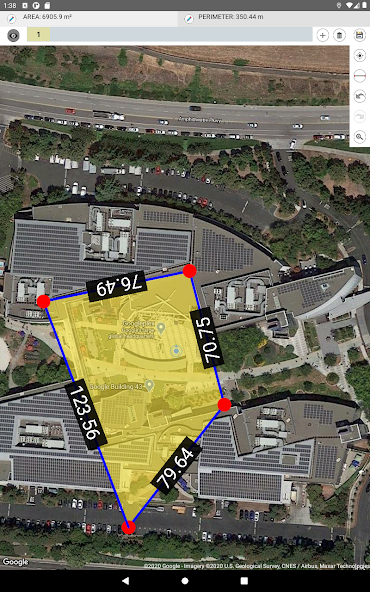
- မြေပုံပေါ်တွင် ဖန်တီးထားသော စာကြောင်းတစ်ခုစီအတွက် ပွိုင့်မှ အကွာအဝေးများကို ပြသသည်။
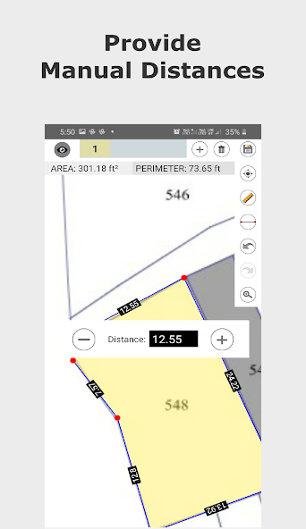
- ကိုယ်တိုင်အကွာအဝေး။ မြေယာနယ်နိမိတ်တိုင်းတာခြင်းများကို ကိုယ်တိုင်ထည့်သွင်းနိုင်ပါသည်။ ထိုလိုင်း၏အရှည်ကို ကိုယ်တိုင်ပြောင်းရန် မည်သည့်စာကြောင်း၏ အကွာအဝေးတံဆိပ်ကို နှိပ်ပါ။ ဓာတ်ပုံများကို တိုင်းတာနေစဉ်တွင်သာ ရရှိနိုင်ပါသည်။
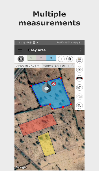
- မြေပုံတစ်ခုတည်းပေါ်တွင် ဧရိယာအများအပြားကို တိုင်းတာရန်အတွက် အလွှာများစွာ။
- သိမ်းဆည်းပြီး တွက်ချက်ထားသော အတိုင်းအတာများ။
- ဧရိယာမျှဝေခြင်းလင့်ခ် သင်သည် သင်၏သိမ်းဆည်းထားသောဧရိယာသို့ လင့်ခ်ကို မျှဝေနိုင်ပါသည်။ လင့်ခ်ရှိသောအသုံးပြုသူသည် လင့်ခ်ပေါ်ရှိ အပ်ဒိတ်ဧရိယာကို ကြည့်ရှုနိုင်သည်။
- ပုံမှန်လက်ဟန်များဖြင့် မြေပုံ၏ အဆုံးမရှိ ချုံ့ချဲ့ခြင်းနှင့် လှိမ့်ခြင်း။
- မြေပုံပေါ်ရှိ အမှတ်များကို ဖန်တီးရန်၊ အပ်ဒိတ်လုပ်ရန်၊ ဖျက်ရန် လွယ်ကူသောကိရိယာများ။
- အမှတ်အသစ်ထည့်ရန် တစ်ချက်နှိပ်ပါ။
- Point တစ်ခုကို ရွေးချယ်ရန် နှိပ်ပါ၊ တည်နေရာကို လွယ်ကူစွာ ပြောင်းလဲရန် ရွေးချယ်ထားသော အမှတ်ကို ဆွဲချပါ။
- ထိုအနေအထားတွင် အမှတ်အသစ်ထည့်ရန် မည်သည့်မျဉ်းကြောင်းကို နှစ်ချက်နှိပ်ပါ။
- ချက်ခြင်းတွက်ချက်ခြင်းဖြင့် ဧရိယာနှင့် အကွာအဝေးတိုင်းတာခြင်းယူနစ်များ ခွဲခြားပါ။
ပါဝင်သော Major India Units များမှာ အောက်ပါအတိုင်းဖြစ်သည်။
- Bigha
- Biswa
- Aankadam
- Shatak
- Perch
- ကြိမ်လုံး
- Vaar (ဂူဂျာရတ်)
- ဟက်တာ
-ဧက
- ဖြစ်ကြပါစေ။
- ဂန္တု
- မာလာ
- Cent
- မြေနှင့်အခြားများစွာသော..
တိုင်းတာမှုပြုလုပ်ရန် နည်းလမ်းနှစ်ခုရှိသည်။
1) မြေပုံများကို အသုံးပြုခြင်း - သင့်မြေ/အကွက်၏ တည်နေရာကို သင်ရှာဖွေနိုင်သည် သို့မဟုတ် မည်သည့်ဧရိယာ သို့မဟုတ် အကွာအဝေးကို တွက်ချက်ရမည်နည်း။
- မြေပုံများတွင်၊ မည်သည့်ကြိုတင်တိုင်းတာမှုမဆို သုညအသိပညာဖြင့် ဧရိယာကို သင်ရှာဖွေနိုင်သည်။
2) ဓာတ်ပုံကို တင်သွင်းခြင်း - သင်သည် မြေ၊ အကွက် သို့မဟုတ် ကျပန်းပုံသဏ္ဌာန်ရှိသော ဗဟုဂံ၏ အခြားပုံတစ်ပုံကို တင်သွင်းနိုင်သည်။ ထို့နောက် တိုင်းတာမှုများပြုလုပ်ရန် တင်သွင်းလာသော ဓာတ်ပုံကို ရိုးရှင်းစွာဆွဲပါ။ ပုံအတွက် စကေးအချိုးကို သတ်မှတ်ရန် ဖန်တီးထားသော ပထမစာကြောင်းအတွက် အကွာအဝေးကို ပံ့ပိုးပေးရန်လိုအပ်သည်။
- သင်ကိုယ်တိုင် သို့မဟုတ် ဒေသဆိုင်ရာ Patvari (အစိုးရစာရင်းကိုင်) မှ လုပ်ဆောင်သော သင့်မြေနယ်နိမိတ်များကို အကွာအဝေးတိုင်းတာမှုများ ပြုလုပ်သည့်အခါ ဤအင်္ဂါရပ်ကို အသုံးပြုနိုင်ပြီး ထိုတိုင်းတာမှုများအတွက် ဧရိယာကို တွက်ချက်ရန် လိုအပ်ပါသည်။
- ရိုးရှင်းစွာအကြမ်းဖျဉ်းပုံကြမ်းဖန်တီးပြီး ဧရိယာကိုအချိန်နှင့်တပြေးညီတွက်ချက်နိုင်ရန် နယ်နိမိတ်များအတွက် တိုင်းတာထားသောအလျားများကိုထည့်ပါ။
- တွက်ချက်ထားသော ဧရိယာအား မည်သည့် ယူနစ်သို့ ကူးပြောင်းနိုင်သည်။ ယူနစ်ပြောင်းပေးသူတွင် ဧကရာဇ်ယူနစ်များ၊ မက်ထရစ်ယူနစ်များ အားလုံးရှိပြီး ပြည်နယ်အသီးသီးရှိ မြေယာမှတ်တမ်းများအတွက် အသုံးပြုသည့် အဓိက အိန္ဒိယယူနစ်များ လည်း ပါဝင်သည်။
ထူးခြားသော အင်္ဂါရပ်များ-
- Coordinate and Spherical geometry ကို အသုံးပြု၍ တွက်ချက်ထားသော ဧရိယာများ၏ 100% တိကျမှု။
- မြေပုံပေါ်တွင် ဖန်တီးထားသော စာကြောင်းတစ်ခုစီအတွက် ပွိုင့်မှ အကွာအဝေးများကို ပြသသည်။
- ကိုယ်တိုင်အကွာအဝေး။ မြေယာနယ်နိမိတ်တိုင်းတာခြင်းများကို ကိုယ်တိုင်ထည့်သွင်းနိုင်ပါသည်။ ထိုလိုင်း၏အရှည်ကို ကိုယ်တိုင်ပြောင်းရန် မည်သည့်စာကြောင်း၏ အကွာအဝေးတံဆိပ်ကို နှိပ်ပါ။ ဓာတ်ပုံများကို တိုင်းတာနေစဉ်တွင်သာ ရရှိနိုင်ပါသည်။
- မြေပုံတစ်ခုတည်းပေါ်တွင် ဧရိယာအများအပြားကို တိုင်းတာရန်အတွက် အလွှာများစွာ။
- သိမ်းဆည်းပြီး တွက်ချက်ထားသော အတိုင်းအတာများ။
- ဧရိယာမျှဝေခြင်းလင့်ခ် သင်သည် သင်၏သိမ်းဆည်းထားသောဧရိယာသို့ လင့်ခ်ကို မျှဝေနိုင်ပါသည်။ လင့်ခ်ရှိသောအသုံးပြုသူသည် လင့်ခ်ပေါ်ရှိ အပ်ဒိတ်ဧရိယာကို ကြည့်ရှုနိုင်သည်။
- ပုံမှန်လက်ဟန်များဖြင့် မြေပုံ၏ အဆုံးမရှိ ချုံ့ချဲ့ခြင်းနှင့် လှိမ့်ခြင်း။
- မြေပုံပေါ်ရှိ အမှတ်များကို ဖန်တီးရန်၊ အပ်ဒိတ်လုပ်ရန်၊ ဖျက်ရန် လွယ်ကူသောကိရိယာများ။
- အမှတ်အသစ်ထည့်ရန် တစ်ချက်နှိပ်ပါ။
- Point တစ်ခုကို ရွေးချယ်ရန် နှိပ်ပါ၊ တည်နေရာကို လွယ်ကူစွာ ပြောင်းလဲရန် ရွေးချယ်ထားသော အမှတ်ကို ဆွဲချပါ။
- ထိုအနေအထားတွင် အမှတ်အသစ်ထည့်ရန် မည်သည့်မျဉ်းကြောင်းကို နှစ်ချက်နှိပ်ပါ။
- ချက်ခြင်းတွက်ချက်ခြင်းဖြင့် ဧရိယာနှင့် အကွာအဝေးတိုင်းတာခြင်းယူနစ်များ ခွဲခြားပါ။
ပါဝင်သော Major India Units များမှာ အောက်ပါအတိုင်းဖြစ်သည်။
- Bigha
- Biswa
- Aankadam
- Shatak
- Perch
- ကြိမ်လုံး
- Vaar (ဂူဂျာရတ်)
- ဟက်တာ
-ဧက
- ဖြစ်ကြပါစေ။
- ဂန္တု
- မာလာ
- Cent
- မြေနှင့်အခြားများစွာသော..
အပ်ဒိတ်လုပ်ခဲ့သည့်ရက်
ဆော့ဖ်ဝဲရေးသူများက သင့်ဒေတာအား စုစည်းပုံနှင့် မျှဝေပုံကို နားလည်ခြင်းမှစ၍ လုံခြုံမှု စတင်သည်။ ဒေတာလုံခြုံမှုနှင့် လုံခြုံရေးလုပ်ဆောင်မှုများသည် သင်၏အသုံးပြုမှု၊ ဒေသနှင့် အသက်အပေါ်မူတည်၍ ကွဲပြားနိုင်သည်။ ဆော့ဖ်ဝဲရေးသူက ဤအချက်အလက်ကို ပေးထားပြီး အချိန်နှင့်အမျှ ပြောင်းလဲနိုင်သည်။

ယခုအက်ပ်က ဤဒေတာအမျိုးအစားများကို ပြင်ပအဖွဲ့အစည်းများနှင့် မျှဝေနိုင်သည်
အက်ပ်အချက်အလက်နှင့် စွမ်းဆောင်ရည်နှင့် စက် သို့မဟုတ် အခြား ID များ

ယခုအက်ပ်သည် ဤဒေတာအမျိုးအစားများကို စုဆောင်းနိုင်သည်
ကိုယ်ရေးအချက်အလက် - ဓာတ်ပုံနှင့် ဗီဒီယိုနှင့် အက်ပ် အသုံးပြုမှု

ဒေတာကို အသွင်ဝှက်၍ အကူးအပြောင်းလုပ်သည်

ဒေတာများဖျက်ရန် တောင်းဆိုနိုင်သည်
အဆင့်သတ်မှတ်ခြင်း၊ သုံးသပ်ခြင်း
၄.၁
သုံးသပ်ချက် ၁.၃၈ သောင်း

Phyo Gyi
- မသင့်လျော်ကြောင်း အလံပြရန်
- သုံးသပ်ချက်မှတ်တမ်း ပြရန်
၂၀၂၅ ဇန်နဝါရီ ၂၉
သေဘာက်မိပါသည္
လူ ၆ ယောက်က ဤသုံးသပ်ချက်ကို အထောက်အကူဖြစ်သည်ဟု ယူဆသည်

MoeMoePaing MoeMoePaing
- မသင့်လျော်ကြောင်း အလံပြရန်
၂၀၂၅ ဇွန် ၂၇
ok
လူ ၂ ယောက်က ဤသုံးသပ်ချက်ကို အထောက်အကူဖြစ်သည်ဟု ယူဆသည်

Aye Mya phyu
- မသင့်လျော်ကြောင်း အလံပြရန်
၂၀၂၄ နိုဝင်ဘာ ၁၉
Like
လူ ၇ ယောက်က ဤသုံးသပ်ချက်ကို အထောက်အကူဖြစ်သည်ဟု ယူဆသည်
အသစ်များ
- Bug fixes*
- Multiple Area divisions(land plotting) possible now.
- Optimized Places Search.
- Added Walking GPS measurements.
- Long Press to add Marker for direction.
- Separated Distance and Area measurements for maps.
- Now you can divide area into two parts!
- Eased area polygon creation using middle points.
- Added Sign in with Google to preserve data.
- Now you can share the link to your created map!
- Now you can add your own custom Units!
- Added Indian Land Area and Distance Units.
အက်ပ် အကူအညီ
phone
ဖုန်း နံပါတ်
+917572857390
ဆော့ဖ်ဝဲရေးသူအကြောင်း
MAROTHIA TECHS
laxman@marothiatechs.com
20-AB, Sun Rise Town Ship Society, Canal Road
Parvat Patiya, Dumbhal
Surat, Gujarat 395010
India
+91 98255 98842